Menu
Shovel Maintenance Optimization
Precision Digging & Loading
- Accurate location of shovel and excavators bucket on real-time basis
- Allow integrated geo-spatial data analysis for drill & blast optimization, orebody visualization and mine plan compliance.
Challenges
- • Unplanned maintenance affects production.
- • Operator behaviour can cause excessive wear, premature failure and unwanted downtime.
Solution
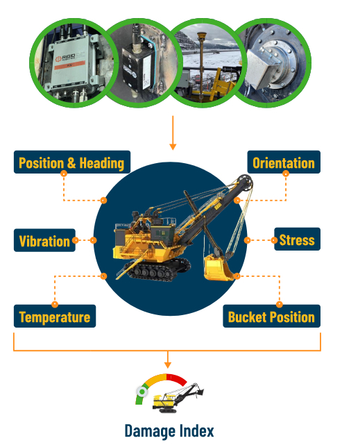
- Shovel Maintenance Optimization tracks Damage Index base on:
- • Vibration at strategic location
- • Digging Conditions of the shove
- • Major events such as Boom Jacking and Swing Impacts
Benefits
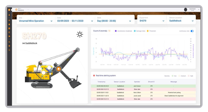
- • Dashboard for maintenance to view, analyze, get customized report
- • Anomaly detection on all of the above using AI
- • Real-time “Cumulative Damage Index” that can be used to plan maintenance events as opposed to fixed time interval.
Machine Support
Remotely managed with RIGIDportal™
- All of our systems can be monitored, maintained, and managed remotely via RIGIDportal web interface.
Case Study: Bucket Sensing
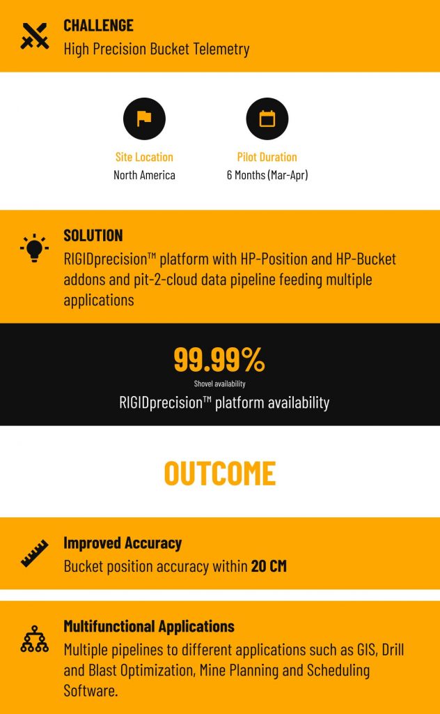
Bucket Telemetry
Objectives
- Accurate location of shovel and excavators bucket on real-time basis
- Allow integrated geo-spatial data analysis for drill & blast optimization, orebody visualization and mine plan compliance.
Solution: RIGIDprecision™ + HPShovel + HPBucket addons
- Scalable real-time data from shovel enabled by RIGIDsense™ hardware
- Advanced bucket-sensing algorithm to determine the accurate location of bucket on a real-time basis.
- Multiple data pipelines for different applications such as payload monitoring, drill & blast optimization, ore sorting, and coal seam visualization
Impact
- Bucket position with less than 20 cm accuracy
- Enabled increase in mine plan compliance, drill and blast optimization and improved recovery
Dig-to-Limit Application
Objectives
- Improve shovel and excavator spatial awareness
- Improve operators’ ability to remove material as per the mine plan
- Reduce personnel exposure to hazardous environment
Solution: RIGIDprecision™ + HPShovel + HPBucket addons
- Scalable real-time data from shovel enabled by RIGIDsense™ hardware
- Dig-to-limit real-time guidance to operators enabled by DIG.D2L application
- Detailed engineering analysis and plan refinements using historical data
Impact
- 5-10% increase in mine plan compliance
- Improved recovery
- Reduction in surveying requirements
- Improved machine productivity and reduced operating cost